Freeway - Corridor
The FAST Dashboard has setup a series of nodes and divide Las Vegas Metropolitan freeways into corridors/sub-corridors, which helps travelers and professionals to investigate specific freeway segments. The nodes are shown on the map of “Segments and Nodes Map” tab. You may view the node ID and description by hovering mouse onto the node to show the node tooltip. The pre-defined corridors are listed in the left pane and organized by freeways. Hover the mouse on the corridor to show its description (origination and destination). Click on the corridor or freeway to select it and pan/zoom and the map to its location, meanwhile the “Corridor Dashboard” displays the dashboard for the selected corridor.
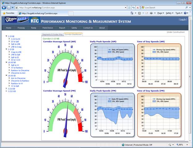
Freeway Average Speed
Depicted as a speedometer, Freeway Average Speed provides the AM and PM average speeds of three different time periods which are ”Past 30 Days”, “30-60 Days” and “Last Year”. Freeway or corridor performance improvement can be observed by comparing the speedometers of different time periods.
Daily Peak Speeds
Daily Peak Speeds is a plot showing a trend of travel speeds over the past two weeks. Every dot connected by the trend line represents true arithmetic average (i.e., mean) peak hour speed of a specific day in the past two weeks. The 15th and 85th percentile speed lines are also plotted and compose the shadow area to show the predominant speed range. Generally, the AM peak hour is defined as 6:00-9:00 am; while the PM peak hour is 3:00-6:00 pm. Where there is a rather narrow shadow band around the mean speed line, this is an indicator that the trip experienced by drivers is relatively reliable. Where the shadow band is much wider (typically, the PM band is much wider than the AM band), this is an indicator that the typical trip is much more varied in terms of travel time, and is therefore is, relatively, less reliable.
Time of Day Speeds
Time of Day Speeds is a plot showing the variances of average travel speeds over 3-hour AM or PM peak. Every dot connected by the trend line represents average speed of the past two weeks at specific 15-minute time slice during the peak hours. The 15th and 85th percentile speed lines are also plotted and compose the shadow area to show the reliabilities. Travelers can choose the best time to avoid the highest peak hour.